#include <Header.hh>
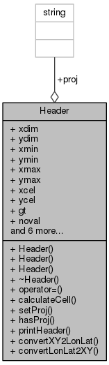
Public Member Functions | |
| Header () | |
| Header (const Header &h) | |
| Header (int xd, int yd, Coord xm, Coord ym, Coord xM, Coord yM, Scalar nv, int nb=1, int gd=0) | |
| ~Header () | |
| Header & | operator= (const Header &h) |
| void | calculateCell () |
| void | setProj (const std::string &projection) |
| int | hasProj () const |
| void | printHeader (const std::string &msg="") const |
| std::pair< Coord, Coord > | convertXY2LonLat (int x, int y) const |
| std::pair< int, int > | convertLonLat2XY (Coord lon, Coord lat) const |
Public Attributes | |
| int | xdim |
| int | ydim |
| Coord | xmin |
| Coord | ymin |
| Coord | xmax |
| Coord | ymax |
| Coord | xcel |
| Coord | ycel |
| Coord | gt [6] |
| Scalar | noval |
| int | nband |
| int | grid |
| int | categ |
| int | minmax |
| Scalar | vmin |
| Scalar | vmax |
| std::string | proj |
Detailed Description
Declaration of Header class.
- Date
- 2003-08-22
- Id:
- Header.hh 5925 2014-03-17 17:55:12Z rdg
LICENSE INFORMATION
Copyright(c) 2003 by CRIA - Centro de Referencia em Informacao Ambiental
This program is free software; you can redistribute it and/or modify it under the terms of the GNU General Public License as published by the Free Software Foundation; either version 2 of the License, or (at your option) any later version.
This program is distributed in the hope that it will be useful, but WITHOUT ANY WARRANTY; without even the implied warranty of MERCHANTABILITY or FITNESS FOR A PARTICULAR PURPOSE. See the GNU General Public License for more details:
http://www.gnu.org/copyleft/gpl.html Header with metadata of georeferenced raster maps.
Constructor & Destructor Documentation
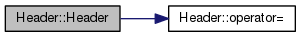
| Header::Header | ( | const Header & | h | ) |
Definition at line 75 of file Header.cpp.
References operator=().
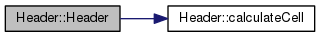
| Header::Header | ( | int | xd, |
| int | yd, | ||
| Coord | xm, | ||
| Coord | ym, | ||
| Coord | xM, | ||
| Coord | yM, | ||
| Scalar | nv, | ||
| int | nb = 1, |
||
| int | gd = 0 |
||
| ) |
Definition at line 43 of file Header.cpp.
References calculateCell(), gt, xcel, xmin, ycel, and ymax.
| Header::~Header | ( | ) |
Definition at line 84 of file Header.cpp.
Member Function Documentation
| void Header::calculateCell | ( | ) |
Definition at line 160 of file Header.cpp.
References gt.
Referenced by GdalRaster::get(), TerralibRaster::get(), TerralibRaster::put(), and GdalRaster::put().
|
inline |
Definition at line 65 of file Header.hh.
Referenced by Projector::createMap(), and GdalRaster::open().
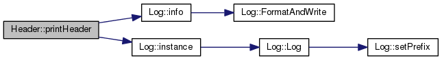
| void Header::printHeader | ( | const std::string & | msg = "" | ) | const |
| void Header::setProj | ( | const std::string & | projection | ) |
Definition at line 142 of file Header.cpp.
References proj.
Referenced by TerralibRaster::createRaster(), and GdalRaster::open().
Member Data Documentation
| int Header::categ |
If not zero the map represents a categorical variable. This way it cannot be interpolated. Obs: it is not saved in files! (there is no room :( ).
Definition at line 93 of file Header.hh.
Referenced by operator=(), and printHeader().
| int Header::grid |
"grid" (not zero) or "pixel" (zero) cell alignment
Definition at line 86 of file Header.hh.
Referenced by GdalRaster::open(), operator=(), and printHeader().
| Coord Header::gt[6] |
The actual gdal geotransform
Definition at line 80 of file Header.hh.
Referenced by convertLonLat2XY(), convertXY2LonLat(), GdalRaster::create(), Header(), GdalRaster::open(), operator=(), and printHeader().
| int Header::minmax |
If not zero 'min' and 'max' are valid values.
Definition at line 99 of file Header.hh.
Referenced by GdalRaster::calcMinMax(), GdalRaster::open(), operator=(), printHeader(), and Raster::setMinMax().
| int Header::nband |
Number of bands.
Definition at line 83 of file Header.hh.
Referenced by GdalRaster::calcMinMax(), GdalRaster::create(), GdalRaster::get(), GdalRaster::iget(), GdalRaster::initBuffer(), GdalRaster::open(), operator=(), printHeader(), GdalRaster::read(), and GdalRaster::write().
| Scalar Header::noval |
Value indicating absence of information.
Definition at line 82 of file Header.hh.
Referenced by GdalRaster::create(), GdalRaster::get(), GdalRaster::iget(), GdalRaster::loadRow(), MapFormat::MapFormat(), GdalRaster::open(), operator=(), printHeader(), GdalRaster::put(), TerralibRaster::put(), and GdalRaster::read().
| std::string Header::proj |
Projection specification (in WKT).
Definition at line 104 of file Header.hh.
Referenced by MapFormat::copyDefaults(), GdalRaster::create(), TerralibRaster::createTeRaster(), Map::Map(), MapFormat::MapFormat(), operator=(), printHeader(), and setProj().
| Scalar Header::vmax |
Maximum map value.
Definition at line 102 of file Header.hh.
Referenced by GdalRaster::calcMinMax(), GdalRaster::getMinMax(), GdalRaster::open(), operator=(), printHeader(), and Raster::setMinMax().
| Scalar Header::vmin |
Minimum map value.
Definition at line 101 of file Header.hh.
Referenced by GdalRaster::calcMinMax(), GdalRaster::getMinMax(), GdalRaster::open(), operator=(), printHeader(), and Raster::setMinMax().
| Coord Header::xcel |
Cell width
Definition at line 78 of file Header.hh.
Referenced by calculateCell(), MapFormat::copyDefaults(), Header(), MapFormat::MapFormat(), operator=(), and printHeader().
| int Header::xdim |
Map width
Definition at line 72 of file Header.hh.
Referenced by GdalRaster::calcMinMax(), calculateCell(), GdalRaster::create(), Projector::createMap(), GdalRaster::get(), TerralibRaster::get(), GdalRaster::initBuffer(), MapIterator::isPastBounds(), GdalRaster::open(), MapIterator::operator++(), MapIterator::operator--(), operator=(), printHeader(), GdalRaster::put(), and TerralibRaster::put().
| Coord Header::xmax |
Highest longitude
Definition at line 76 of file Header.hh.
Referenced by RequestFile::_setProjection(), calculateCell(), MapFormat::copyDefaults(), MapFormat::MapFormat(), GdalRaster::open(), operator=(), and printHeader().
| Coord Header::xmin |
Lowest longitude
Definition at line 74 of file Header.hh.
Referenced by RequestFile::_setProjection(), calculateCell(), MapFormat::copyDefaults(), Header(), MapFormat::MapFormat(), GdalRaster::open(), operator=(), and printHeader().
| Coord Header::ycel |
Cell hight
Definition at line 79 of file Header.hh.
Referenced by calculateCell(), MapFormat::copyDefaults(), Header(), MapFormat::MapFormat(), operator=(), and printHeader().
| int Header::ydim |
Map height
Definition at line 73 of file Header.hh.
Referenced by GdalRaster::calcMinMax(), calculateCell(), GdalRaster::create(), Projector::createMap(), TerralibRaster::get(), GdalRaster::get(), MapIterator::isPastBounds(), GdalRaster::open(), operator=(), printHeader(), TerralibRaster::put(), and GdalRaster::put().
| Coord Header::ymax |
Highest latitude
Definition at line 77 of file Header.hh.
Referenced by RequestFile::_setProjection(), calculateCell(), MapFormat::copyDefaults(), Header(), MapFormat::MapFormat(), GdalRaster::open(), operator=(), and printHeader().
| Coord Header::ymin |
Lowest latitude
Definition at line 75 of file Header.hh.
Referenced by RequestFile::_setProjection(), calculateCell(), MapFormat::copyDefaults(), MapFormat::MapFormat(), GdalRaster::open(), operator=(), and printHeader().
The documentation for this class was generated from the following files: